![]()
THE DEVELOPMENT OF THE KING'S HIGHWAY THROUGH THE VILLAGE OF OLDHAM FROM 1700 TO 1800 Thumbnails link to larger versions Many of the old roads that we can see today, started life as little more than beaten tracks… customary routes serving to connect the settlement of one tribe with that of another. These tracks simply followed the natural contours of the land and did not have any type of hardened surface to protect them against the weather or the footfall of man and beast. Other roads especially the great Trading routes have their origins in Pre-history, roads such as the Ridgeway and the Icknield way and the Fosse Way spanned great swathes of the country, often keeping to the high ground just occasionally descending to the valley floor where a river could be forded. With the coming of the Romans, the road infrastructure in this country was transformed. They brought with them the engineering know how of how to construct long straight trackways, that took little account of the natural obstacles in the topography of the landscape. They also had metalled surfaces that could withstand the vagaries of the British weather. Although these great roads were constructed primarily for the Roman Legions , it is quite likely that the local population would have been quick to take advantage of these newly constructed super highways!. However once the Romans had departed in the early part of the 5th century the engineering were-withal seems to have left with them, however it would be reasonable to assume that for a few generations after they left some residual knowledge of road maintenance would have been retained by the native population. So as the Roman occupation ended, that period referred to by historians as the Dark ages began to take hold, and it would seem that road construction was not to high on the agenda of the hordes of invading Angles and Saxons, particularly at that time just after the Romans had left, However after a couple of hundred years or so when things had had time to calm down….. the one time invading Saxons had now become the settlers, and it was at this period which saw the birth of many of the minor roads we see still in existence today. Starting life as Trackways they would have gradually been widened to accommodate livestock, and wheeled transport.Over many generations these would have become well worn, well established beaten tracks that would have served to connect one village or town with another. Of course lots of these early Trackways have long since disappeared however many remain, primarily in the form of ‘B’ Roads, green lanes and footpaths. The Kings Highway…A mediaeval concept A couple of centuries after the Norman conquest saw the signing of Magna Carta in 1215 and the birth of English Common Law.As the statute began to expand we find the earliest reference to the Kings Highway. So what was it? And how did it come to be used in everyday parlance? Well to the average citizen of this country back in the 13th and 14th centuries the Kings Highway was in reality more of an abstract concept than an actual physical roadway, it was first framed in English Common Law as follows:- “A perpetual right of way in the Sovereign for Himself and his Subjects over anothers Land.” So what we have here written into law was not necessarily concerned with a physical road as such …but an easement, the idea of a public right of way that could connect one place with another, crossing the land, unimpeded by boundaries… even those conferred by Title that might be enjoyed by both Sovereign and the Commoner alike. In essence it was all about Access So in purely practical terms in order for a Monarch to govern effectively, it was vital that roadways had to be both extant, and that they were subject to maintainance. Why was this? Because the two key pre-requisites you needed to govern effectively, was firstly the ability to move your armies around to deal with any potential aggression from your enemies both at home and abroad, as well as having to suppress the odd uprising or two from the indigenous peasant classes!. The second pre requisite you won’t be surprised to hear was that as Monarch, you could get your people out and collecting taxes for you! So having unimpeded access to all your subjects was essential Of course it cut both ways…. being one of his Majesties subjects then the Highways were the means by which you could do business. You could move your goods and livestock to the market place either in your own town, or in the town of your neighbours without being accountable to the Landowner upon whose land the road crossed. The Highways were also the means by which you could travel to see nearby relatives. The Kings Highway from Ashton to Oldham
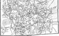
The other way it wended its way out of Oldham, along Fog Lane (Lower King St) for a few hundred yards before becoming what was then known as Broadway Lane (not be confused with Broadway in Royton or Chadderton by the way) it then went through Primrose Bank and then down to Hathershaw at a place known as Cross, along Hollins road through Failsworth and onto Manchester. So what do we know about this road. And why might it have developed? It has been speculated that the old Highway to Oldham, could well have had its origins in the salt producing towns of Cheshire. . Starting in Nantwich the road would have passed through Sandbach, Congleton, Macclesfield, Stockport, Hyde, Ashton, and then to Oldham. Salt of course was considered a very important commodity back then, highly prized as a preserving and cullinary agent, in fact it was considered so important , that the Romans even paid their armies in it.(origin of the word salary) So it seems eminently plausible that from the very earliest of times in the towns history, a road might well have emerged and gained in importance, simply on the basis of the supply and demand especially where the commodity involved was considered essential in the lives of the local community. Sam Andrew one of Oldhams local chroniclers of the late Victorian period once described the roads that lead out of Ashton as… and I quote Antediluvian…which of course meant pre flood or before the Ark! Hinting with his tongue firmly in cheek at their great age and attrocious condition.. Interestingly the Romans… the masters of the straight road, were active in the area and they had cut a road not far from here, one section running from Manchester to Castleshaw, a portion of it which passed over Glodwick Lows, however it seems fairly conclusive that no Roman road ever existed between Ashton and Oldham.
The course of the Old Highway from Ashton to Oldham Taking the Oldham road out of Ashton, bear left onto Taunton Rd - Turn Left into Newmarket Rd, follow until turning right into Downing St. Cut through the Lane as it enters the woods and follow until reaching a junction with Tree House Bank Farm on your right, continue ahead, following the old lane into Boodle wood, crossing the River Medlock close by to the long demolished Riversvale Hall on your left. A little further on the right is Valley farm. Continuing on, you will pass Riversvale Farm on the left until bearing right into Knott Lanes. From here follow the road until reaching Ashton Rd (The actual line of the old road is difficult to follow here so as an option you could turn left into Byrth road just before Ashton Rd and follow it round until picking up Keb Lane).Follow Keb Lane passing through Bardsley until it merges with Park Bridge Rd, after some time the road changes to Waggon Rd, Follow until you you reach a split in the road, bear right into Alt Hill Rd and travel a little further until the road bears left into Mill Brow Lane follow the Lane until reaching Keverlow Farm on the right you are now on Alt Lane. Follow all the way passing Alders Farm on your right and a little further on Top ‘o’th Owlers/Alders on your left. Carry onto the junction with Abbey Hills Rd turn Left and then pick up Roundthorne Rd passing by the Dog and Partridge on your left followed by a quaint row of houses called Roxbury Cottages.The Lane then went all the way up to the junction with Glodwick Rd known then as Three Lane Ends.
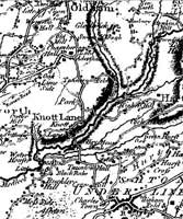
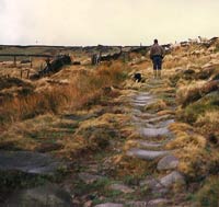
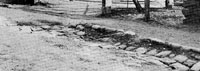
My delineation of the course of the old Highway based partially on the 1804 map and the word of previous local historians. From here on things become far less clear, Hartley Bateson in his History of Oldham claims the old road then went along what is now Cheetham St down onto Shaw Rd then known as Foul Leach Lane and then along Castle Mill St, to the Bridge at Mumps which spanned the river by means of a platting or flagged footbridge. However, if the map of 1804 is examined, it does not apparently show the existence of a road. However if we follow the line of buildings (marked on the map with an oval) closely, it will be noted that they are following the line of what is now Castle Mill Street, as suggested by Bateson.We could therefore conclude that these properties were indeed following the line of the old Highway, running parallel with them. From here it wended its way past Wallshaw then passed Rhodes House (Although that was not built until much later) and on to what is now Bow St, from here it went passed Dolstyle Farm (Later renamed Potters yard). Who was using the old Highway and for what purpose? So as early as the fifteenth century right the way through to the very late eighteenth century the transportation of essential commodities such as wool, salt, coal and minerals relied on the work of the Carriers these were the Hauliers of their day, They were the very lifeblood that flowed along Britain's often very inadequate infrastructure. Inhabitants in the Oldham area would have been used to seeing Packhorse trains some twenty to forty horses strong, transporting salt from the Cheshire plain or from the mineral rich areas of North East Lancashire such as Limestone, coal and iron ore .. These trains were also known as Galloways (due to the type of horse that had been bred in that part of Scotland for this very arduous work). The breed, unfortunately, is now extinct. The breed had the perfect stature to carry really heavy loads of coal and minerals across the Pennines. It was a broad backed, very surefooted horse and had bags of stamina. Old Packhorse Track
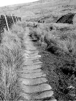
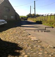
In times past there were many classifications of road : there were Highways, Byeways, footways, Cartways, Horseways Carriageways, Bridleways, Ridgeways, Coach Roads, Drovers' Roads and Turnpikes to name but a few, each being determined by its width. A Drovers' Road for example could be as wide as 30 to 40 feet in width whilst a Packhorse track as little as 2 foot wide. In his book published in 1949.. The Roof of Lancashire by Herbert Collins he makes what I consider to be a crucial observation.... he notes in one of his diagrams that throughout this part of Lancashire the predominant width of the old roads that criss-crossed this part of Lancashire were, on average, about 11 feet, and he further asserts that they were nearly all used as Packhorse roads. Technically speaking the Old Highway from Ashton falls into this category and they were known as cartways, allowing the passage of two carts or wains simultaneously.
Knott Lanes, Keb Lane Riversvale Lane gave similar results, however, Waggon Lane did not, but I think this might have been widened to cater for the traffic heading up to Park Bridge. Roundthorne Road and Glodwick Road have also been much altered. Alt Hill Road proved interesting as the road here reduces down to 8 feet in parts, so it's quite possible that this section of the road might have originally been a Packhorse trail rather than a fully paved cartway. After my field trip I was pretty happy that the old road could indeed be classified as a cartway and it would without doubt have borne witness to many a Packhorse team in its day. After its upgrading to a metalled surface it would have been quite capable of withstanding the heavy iron rimmed wheels of the carts that would have trundled up and down it. Road Maintenance OK, so once the road had been metalled, it then fell to the local inhabitants to provide for its upkeep So the requirement to maintain the Highway was in the hands of the Surveyor who would have been appointed by the Parish … and from all accounts this seems to have been a rather onerous task . In the year 1553 under Phillip and Mary a statute for the repair of the Kings Highway under the supervision of a voluntary surveyor of highways would require the inhabitants of the Parish to give up four days work without payment.. This was four days of free labour given up by those living within a given distance of the road. This was then further increased to 6 days free labour by Queen Elizabeth in 1563. Six days without any form of payment would have presented quite a challenge to the local inhabitants, However one of the very few upsides was that free ale was to be provided by the Parish authorities just to try and keep the workers onside.
The Surveyor of the Highways of 1765 also mentions sections of the Highway that were in need of repair. So in that year improvement work had been carried out at Buggard Hole, Hargreaves, and Red Tom Nook, and there was also some maintenance work carried out in the section known as Hathershaw Lane.
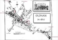
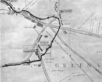
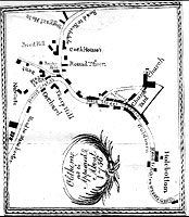
Oldham Village plan Okay, I’d like to move on now if I may, to consider the route of the old Highway through the village proper.
Whether it is even contemporaneous with the mid-eighteenth century is open to debate! In my view, it is what one might call, to quote Bamber Gascoigne, a starter for ten … a reasonable assessment of what the town might have looked like in the year 1756. However, my research will show quite conclusively that it is a far from complete record of the places that were in existence in the village at that time.
But is this depiction, shown in the plan, true ? Well, I have little doubt that Water street is indeed old, but as for it being the continuation of the old highway leading from Main/High Street, I am not so sure. Let me offer some counter evidence to raise a question mark over the matter.
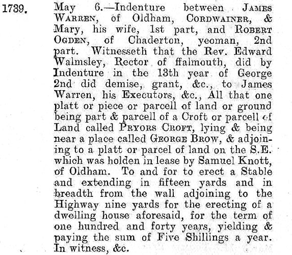
So what this is saying, in laymans terms, is that in the thirteenth year of King George the second (1740) ... a certain James Warren rented a parcel of land to build a stable 15 yards long by 9 yards in breadth at a place called Priors Croft near a place called George Brow. From the wall Adjoining to the Highway,
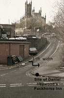
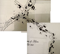
You can see Bardsley Brow shown here on my own map which depicts the layout of the town as it would have looked around about the mid eighteenth century, The map I have produced is based on actual recorded data contained in the Land Tax records and also from the Lancashire alehouse recognizance lists, which record the date, the name of the Inn and the name of the landlord who was running it. So, in essence, what the Indenture reveals, is that in the year 1740, the Highway must have been running down what was then known as George Brow, the main thoroughfare through the village could not therefore have been Water street as indicated on the 1756 plan. Actually, I do have a theory about Water Street, the first recorded mention I can find for it is in 1746, and as indicated on the 1804 map (which is the earliest professionally surveyed map of the town we have) shows it to be here running down into the Tythe barn area I just wonder if Water St could in fact have been a very ancient byeway that could have been used for generations by the local farmers to take their annual tythes of corn or oats down the hill to the old Tythe barn. The earliest record I can find, for the collecting of tythes dates back to 1452, so if my postulation is accurate this would make Water St very old. The confusion about it being the old Highway is that it may have been first paved in the 1740’s giving it the appearance of a highway. Its width is around the 11 foot mark keeping it consistent with the old highway dimensions as previously discussed. I think if we can accept the evidence presented in the Indenture of 1739, that the course of the real Highway had always been on George Brow and, back then, would have been no more than 11 feet in width. It was with the coming of the turnpikes, allied with a steadily increasing population from the late 1770’s, that the decision was taken to widen and pave the George Brow section of the old highway in addition to the Main St, Market Place and the road to Rochdale ... all to accommodate the inevitable expansion in traffic coming from Manchester and Rochdale.. It is sort of understandable, therefore, that people writing in the next century and seeing Water St as a somewhat quaint backwater lane, looking every bit like a remnant of the old Highway, would in my view have been only too quick to jump to the conclusion that they were looking at the original course of the old road! Return to Top of Page RETURN to Members' and Visitors' Menu Page
|
|||||||||||||||||||||||||||||||